The Lancashire Coastal Way
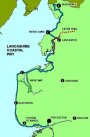
The 137 mile way marked route extends from Silverdale to Freckleton by way of Knott End and Fleetwood using the ferry to cross the River Wyre. The route follows the Lune and Ribble Estuaries and is ideal for bird watching. Parts of the route are suitable for people with impaired mobility.
The first part of coastal way was opened in September 1991.
I now have details of the route of the Coastal Way and have taken a number of pictures of the path between Freckleton and Lytham. More details to come when I have sorted them out.
The path from Bunker Street to the Boat Yard was much improved during 2005 although little seems to have been accomplished since. The path as far as the Naze is reasonable at most times of the year but can flood in places. The section of path along the coast from the Naze to Warton varies between reasonable and impassible, depending on the time of year and the tides.
Lancashire Coastal Way Survey.
Ron McCombe Associates Ltd have completed a survey of a section
of the Lancashire Coastal Way for the Lancashire Countryside Service
from Freckleton to The Dolphin Public House at Longton a distance
of 22 miles.
A PDF map (895Kb) of the Lancashire Coastal Way can is available by <clicking here>